Printable Cruise Map!!
The route was chosen to minimize difficult left turns, avoid traffic circles, avoid highways, avoid closed bridges, and to try to take a more interesting scenic route than I-195 to US-9. We will pass the beach/ocean area, farm land, Allaire State Park, and numerous streams and lakes, just as examples.
· Cruise is approximately 26 miles and should take roughly an hour
· Cruise route:
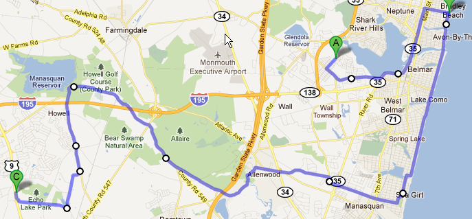 ·
· In the event of rain, we will reschedule to Saturday 10/1, staying in line with the cruise night schedule.
· As always, there will be zero tolerance for any club member actions that puts NJFBOA in a bad light. So no speeding, acting up, etc. Of course we know this warning is not required but we wanted to mention it anyway.
Starting Point – Evans Area in Wall
We are going to meet at the big parking lot of the former US Army base Evans Area.
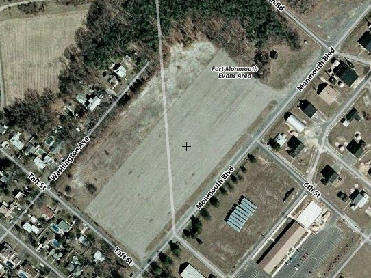
What is Evans Area? It was a US Army research facility. Take a quick look at these links for a brief rundown of some of the history. I hear other interesting things went down there that are still classified. We are just meeting here; there is no tour, etc.
http://www.infoage.org/
http://en.wikipedia.org/wiki/Camp_Evans
It is easy to get to off Belmar Blvd, via the GSP exit 98 to RT 138, and off Rt 18
Cruise Directions (
printable ones coming soon)
· Exit right out of Evans Area parking lot onto Monmouth Blvd. Note this is a 25 MPH residential area
· Left onto Belmar Blvd. This is one of only three uncontrolled lefts we are making and probably the hardest. There is no light so be careful. I believe there is enough shoulder on BB for the lead cars to wait.
· Take Belmar Blvd all the way to Rt 35 N. There is a Shell Station on the right.
· Turn left onto Rt 35 N
· Take Rt 35 N around the Shark River and head south over the bridge.
· Stay to the right on the bridge as we will go straight onto Memorial Drive.
o Don’t follow the left lane onto the overpass for RT 35 N.
o If you miss it, fear not, Follow Rt 35N and make a right at the 1st light onto Steiner Ave, then make a right onto 6th Ave and you are back on the route.
· Take Memorial Drive to Bradley Beach. The light at the train station is 6th Ave/Brinley Ave.
· Make the right onto Brinley Aveo Take Brinley all the way to the beach.
· Turn right onto Ocean Avenue in Bradley Beach.
o Ocean Ave is a 25 mph zone in the summer, so if your GPS says 35 mph ignore it (signs may not change right after Labor Day).
o Remember pedestrians in walkways have the right of way so be prepared to stop anywhere on Ocean Ave.
· When Ocean Ave ends in Sea Girt,
bear right and then make the next left onto 1st Ave.
o Watch your speeds
· 1st Ave bends around a park and then kind of forces you to
make a left onto Washington Blvd/Sea Girt Ave.
· Follow Sea Girt Ave across Rt 71 and Broad St, Manasquan, and across Rt 35 in Wall.
o You will see a GMC/Buick Dealer on the left
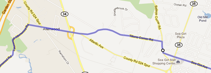
· Turn right onto Baileys Corner Rd
· Take the 2nd left onto Tiltons Corner Rd
· Follow Tiltons Corner to the end. There is a stop sign and a firehouse is across the street.
· Make the right onto Atlantic Ave/County Rd 524 Spur
· Follow Atlantic Ave to the end: under Rt 34, past the blinking light, the bicycle trail and the Allenwood General Store.
· At the stop sign make a left onto Lakewood-Allenwood Rd
· Lakewood-Allenwood Rd becomes Squankum-Allenwood Rd after you cross the GSP.
· It then merges with Herbertsville Road and CR549 and becomes CR549. Squankum-Allenwood Rd has the right of way at the merge.
· Blewitts salvage yard is on your left after the merge
· When 549 comes to the traffic light at Lakewood-Farmingdale Road/CR547 it turns into Old Tavern Rd in Howell
· Stay straight through the light at Old Tavern Rd and CR547
· At the big left hand bend Old Tavern Rd becomes Oak Glen Rd
· Turn right onto Lanes Pond Rdo We were going to take Maxim Southard Rd but the bridge is out at Echo Lake
o Watch your speed.
· After the lake
Turn right onto Lanes Mill Rd
· Just before Rt 9 is the entrance to the mall where Chick-Fil-A is located.